Seasons and tides in the South Pacific Region

This could be almost anywhere in the lower elevations of Costa Rica, but it’s the view from our house, Villa Sur, in Dominical…
When is the best time to go to Dominical?
According to climate data from 1992 to 2021, the wettest month is October, with an average rainfall of 12+ inches, and the driest month is March. But, like many things in life, it’s more nuanced than that.
While we’ve been to Dominical in every season with the exception of December holidays, I don’t think we could pick a “best time of year”. When you look at the prices and availability of rental properties in the area, mid-December to mid-April are the most popular. The weather is generally drier than the North American summer and fall, and the season’s popularity may reflect that lots of Americans, Canadians and Europeans are trying to get out of the cold and snow. So, good weather -> higher prices -> more crowds. However, if you don’t mind some rain, you can save 40% or so by booking in September and October (at least at Caballitos del Mar.)
The following rainfall graphic is from an exceedingly good site, the Costa Rica Guide, and their website is full of helpful information regarding the rest of your trip, after you’ve visited Caballitos del Mar. For example, they have a cool rainfall map that allows you to see the rainfall in different locations around the country for every month of the year.

The map above is static, so visit Costa Rica Guide to see the animated version. I have selected Dominical in the map above, so you can see that it rains some in the summer, but it really rains in the “Green Season”, in September and October. In fact, some businesses close for several weeks to a month during this time since tourism is at a low ebb.
Another source of climatic information is WeatherSpark, which has a ton of information about just about anywhere in the world. I copied a few of their charts below, but I recommend that you go to the site and see the wealth of information they offer, especially for travel planning.
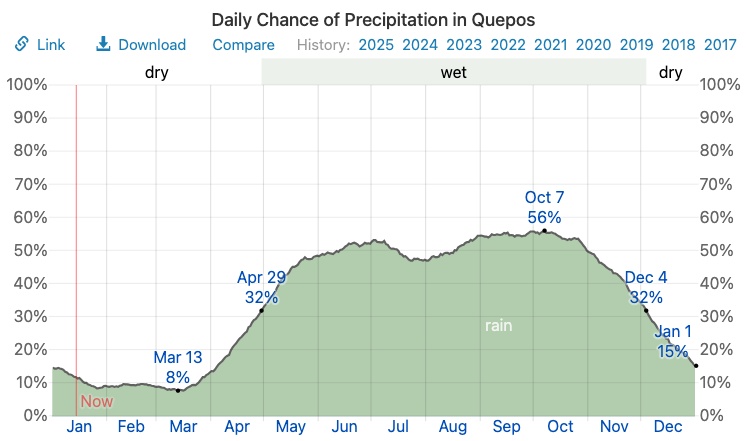
Note that this information is for Quepos, which is about 40km north of Dominical, but it’s the closest city for which WeatherSpark has information. This generally confirms that the wet season is May through October. As you travel farther south than Quepos and Dominical, the “dry” season gets shorter and shorter until rain is pretty likely year-round.
However, and it’s a big however, we love the rain, and the electrical storms and downpours are exciting and can be a relief on warm evenings. Generally, you’ll wake up to clear skies, and clouds will begin to form in the early afternoon. Rain may start an hour before sundown, and it occasionally really lets loose. In return you get lush, tropical forests and extraordinary biological diversity.
When is sunrise and sunset during the year?
I don’t know if you consider this a pressing question, but it’s nice to know when to plan for dinner reservations at sunset, or whether you’re concerned about the morning sun peaking in your bedroom at o’dark thirty. There’s a wonderful site that shows you sunrise and sunset for anywhere in the world, including our favorite Dominical. The answer is that virtually every day is 12 hours hours long due to Dominical’s proximity to the equator (and no daylight savings time to mess up the clocks!) You can expect daylight (sunrise to sunset) to vary from 11:40 in the end of December to 12:40 in June. The sun rises around 5:30am to 6:00am, and sets around 5:30pm to 6:00pm
Tides
One of the biggest draws, after the wonderful diversity of plant and animal life in Dominical, is surfing. The water is warm, the waves are wonderful, there are all sorts of schools and camps to get you started, and you can walk, with your board, directly from Caballitos del Mar to surfable waves.
Costa Rica has semidiurnal tides, meaning that there are two high tides and two low tides every day, with a range of 8 to 9 feet. high and low tides are virtually identical, as the following graph shows. This information is from SurfLine, and is actually calculated for Bahia Uvita, which is about 11 miles (18 km) south of our villas. (Incidentally, we tried to get a SurfLine camera installed at the villas, but could not find a suitable line of sight due to the trees.) More information on Surfing in Dominical can be found here!
Water temperature varies very little during the year (about 2 degrees F). You can expect the ocean to be 83 to 85°F when you surf or swim.

We realize that this is a static graph showing the tides, but it does illustrate the sinusoidal nature of the tides in all of Costa Rica. Daily highs and lows are close to the same, and the average range is about 8.5’.